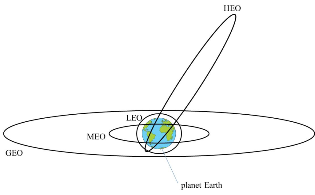
5G Satellite Classes
At one side, our planet Earth attracts as a main body the much smaller satellite, which motion is dictated as a consequence by the laws of Kepler. On the side, the environment of Earth can be also constraining: the higher density of the atmosphere, debris from launchers and former satellites in the lower altitudes, as well as higher energy particles trapped in the Van Allen belts between 2000 and 8000 km’s altitudes are to be avoided.
Considering above two constraints we can define several classes of orbits that are used for communication satellites.
- GEOstationary– GEO satellites are located precisely in the plane of the Equator at an altitude of 35 786 km, these satellites rotate at the same rate as the Earth’s rotation: a GEO satellite stands still with respect to Earth. This property help in creating a continuous coverage with a single GEO satellite.
- Non-Geostationary Orbiting NGSO satellites: NGSO satellites do not stand still with respect to Earth. Should service continuity be required over time, a number of satellites (a constellation) is required to meet this requirement; the lower the altitude the higher the number of satellites. Different classes of NGSO satellites are listed below:
- Low-Earth Orbiting: LEO satellites are at altitude ranging 500 km and 2000 km, and with inclination angle of the orbital plane ranging from 0 to more than 90 degrees. These constellations are placed above the International Space Station and debris, and below the first Van Allen belt.
- Medium-Earth Orbiting: MEO satellites are at altitude ranging from 8000 to 20,000 km. The inclination angle of the orbital plane ranges from 0 to more than 90 degrees. These constellations are placed above the Van Allen belts.
- Highly-Eccentric Orbiting: HEO satellites are at a range of operational altitudes (the orbit of such satellites being designed for the spacecraft to be exploited when the vehicle is closer to its apogee – the higher part of the orbit -) between 7,000 km and more than 45,000 km. The inclination angle is selected so as to compensate, completely or partially, the relative motion of Earth with respect to the orbital plane, allowing the satellite to cover successively different parts of Northern land masses (e.g. Western Europe, North America, and Northern Asia).
References:
- 3GPP TR 22.822: Study on using Satellite Access in 5G
Related Posts: